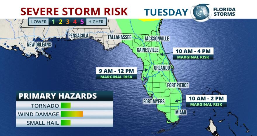
Thunderstorms capable of producing minor wind damage, or even an isolated tornado, are possible across the Florida peninsula today.
The storms will be scattered in nature, meaning not everyone will experience the activity. There will three areas of interest, where chances of a severe storm are slightly higher than surrounding locations.
North Florida: Showers and thunderstorms are likely to develop quickly ahead of advancing cold front near or just west of the U.S. Highway 301 corridor from just west of Jacksonville, to Gainesville and Crystal River. Minor wind damage and frequent lightning will be possible with the strongest cells as they move quickly to east toward the First Coast by midday.
Central Florida: Confidence in when, and to what extent, strong thunderstorms will develop in central Florida is a bit lower. The line of cells developing in North Florida during the morning hours will have the potential to extend as far south as the I-4 corridor, but will be mainly confined to areas near Orlando and Daytona Beach through midday. A second round of thunderstorms have the potential to develop near and south of the Tampa and Sarasota metro areas by early afternoon, but questionable levels of instability may mitigate or prevent the strong thunderstorm potential in these areas.
South Florida: A complex of strong thunderstorms is expected to traverse The Everglades Tuesday morning and approach the metro areas of Miami, Fort Lauderdale and West Palm Beach by late morning. Minor wind damage, and even an isolated tornado or water spout, will be possible with the stronger cells embedded in this activity as it approaches.


