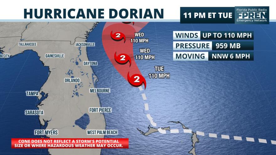
Hurricane Dorian continues pounding Florida’s east coast this evening as the Category 2 storm moving out in the Gulf of Mexico, parallel to the state.
The storm’s outer bands are producing tropical storm force winds, periods of heavy rain and storm surge across central Florida.
Dorian is moving toward the north-northwest and is picking up speed. Florida is still outside the cone of uncertainty.
LATEST ON THE STORM
As of 11 p.m. Tuesday, Dorian, still a category 2 storm, is now heading north-northwest at 8 mph. It remains a Category 2 storm with maximum sustained winds at 110 mph. Dorian is still forecast to parallel the eastern coast of Florida as it continues to gain latitude. Minimal pressure still sits at 959 mb.
WEATHER: Storm track, hourly outlooks, 7-day forecasts and weather alerts
FORECAST UPDATE
The continually growing eye and expanding hurricane and tropical-storm-force winds are due to the gradual weakening of Dorian. Some reorganization is expected as it tracks through warm, uninterrupted waters of the Atlantic, however high vertical wind shear should weaken any gains in wind speed and expand the area of the storm as it approaches the Carolinas.
“Tropical storm winds are expected over much of the Florida east coast today and Wednesday,” said Ray Hawthorne, a meteorologist with the Florida Public Radio Emergency Network. “It may take until Wednesday night or Thursday morning for the threat of tropical storm conditions to completely leave the state.”
Storm surge flooding may exceed 4 feet along parts of the Atlantic coast, Hawthorne said. Rainfall amounts of 4-8 inches are possible, particularly near the immediate coastline. Forecasters say Dorian should to pick up forward motion as it moves just off the Georgia and Carolina coasts Thursday and Friday.
The center of Dorian is expected to brush the South Carolina and North Carolina coasts on Thursday through Friday morning.
ALERTS: Download the Florida Storms app to get severe weather notifications

STORM DETAILS
Areas in the Treasure Coast of Florida will continue to experience tropical storm conditions tonight. Tropical storm conditions are expected to begin in North Florida and Georgia late tonight or early Wednesday.
At high tide, areas from the Volusia/Brevard county line to the Savannah River in Georgia, could see storm surge of 3-5 feet, and 2-4 feet from Jupiter Inlet to the Volusia/Brevard County line. Dorian also could produce life-threatening surf and dangerous rip currents.
Coastal areas from West Palm Beach to Georgia could experience 3-6 inches of rain through Friday, with isolated totals of 9 inches.
COMPLETE COVERAGE: Dorian stories from WUSF and throughout the state
WATCHES AND WARNINGS
A flood warning has been issued for Cypress Creek at Worthington Gardens in Pasco County and the Peace River at Zolfo Springs, and the Tampa Bay area is under small craft and rip current advisories.
A storm Surge Warning is in effect for Jupiter Inlet to Surf City, NC
A Hurricane Warning is in effect for Sebastian Inlet to Ponte Vedra Beach
A Hurricane Watch is in effect for north of Ponte Vedra Beach to the Savannah River
A Tropical Storm Warning is in effect for Jupiter Inlet to Sebastian Inlet
A Tropical Storm Warning is in effect for north of Ponte Vedra Beach to The Savannah River
Florida Public Radio Emergency Network meteorologist Ray Hawthorne contributed to this report.Florida Public Radio Emergency Network meteorologist Ray Hawthorne contributed to this report.


