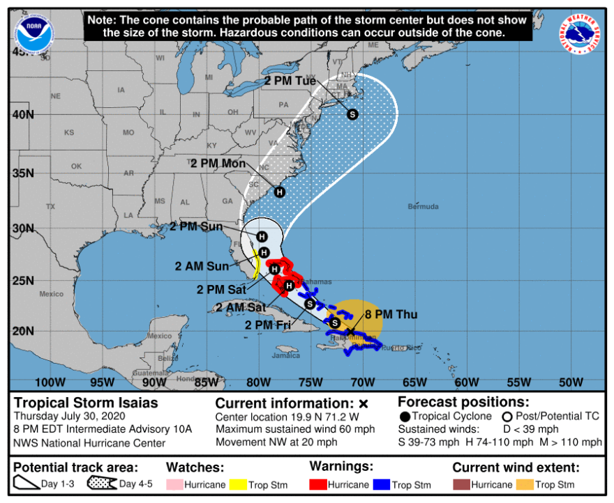
Tropical Storm Isaías is forecast to become a hurricane by the time it approaches the Atlantic Coast of Florida Saturday. A Tropical Storm Watch has been issued from Ocean Reef to Sebastian Inlet, or roughly from Miami to Fort Pierce.
The ninth named storm of the 2020 Atlantic hurricane season formed late Wednesday night.
A hurricane warning is in effect for the northwestern Bahamas, while tropical storm warnings remain in effect for the Dominican Republic, Haiti and the southeastern Bahamas as Isaías has become better organized, according to the National Hurricane Center.
As of 8 pm Thursday, Isaías was located about 45 miles west-northwest of Puerto Plata, Dominican Republic, and moving northwest at 20 mph, according to the hurricane center. Maximum sustained winds are near 60 mph with higher gusts.
It could bring around 4-8 inches of rain to Puerto Rico, the Dominican Republic, and northern Haiti, with isolated totals of 12 inches that could cause life-threatening floods and mudslides, forecasters said.
Rain turned several streets into fast-flowing rivers and toppled trees and some telephone and electrical cables in Puerto Rico. The National Guard rescued at least 35 people in the U.S. territory, including two newborns.
The National Hurricane Center said Tropical Storm Isaías could be strengthening, despite experiencing some interaction with the mountainous island of Hispañiola. Forecasters also noted that the center may be reforming on the north side of island where stronger thunderstorms have formed. As Isaías pulls away from the island, further strengthening is anticipated for at least the next 36 hours.

The center of the storm is forecast to be near the southeastern Bahamas by late Thursday night, the Central Bahamas Friday night, and near or over the northwest Bahamas and near south Florida on Saturday.
A decrease in forward speed is possible Saturday, at which point it would be sitting over very warm waters in the Gulf Stream between Miami and The Bahamas. However, also at this time, there are mixed signals from forecast model simulations on how strong upper-level winds may be. It's possible that Isaías' intensification might be slowed or even halted by these winds.
In the National Hurricane Center's "Key Messages" released Thursday afternoon, Senior Hurricane Specialist Dan Brown said there is a risk of rain, wind and storm surge impacts from Isaías in parts of Florida, but that it was still "too soon to determine the magnitude and location" of those hazards. Even though the newest information suggests the center of the storm would stay offshore, residents from the First Coast to Miami are urged to stay vigilant and monitor the progress of Tropical Storm Isaías.
Florida Public Radio Emergency Network meteorologist Dr. Athena Masson said effects from Isaías in the greater Tampa Bay region are possible, but it's too soon to determine specific timing or magnitude.
“The next several hours will be crucial as Isaias passed over Hispaniola. The mountainous island could help to weaken the storm,” said Masson. “The majority of weather models are agreeing this afternoon that Isaias may favor eastern parts of the Sunshine State, which would limit the extent of rain and wind this far west.”
Masson says this forecast still could change, but at the present time does not expect significant impacts to our area.
Additional information from the Associated Press.


