Hurricane Delta made landfall early Wednesday morning on the Yucatan Peninsula as a strong Category 2 storm that could intensify once it re-emerges in the Gulf of Mexico on a path toward the northern Gulf Coast later this week.
Delta made landfall near Puerto Morelos around 5:30 a.m. It is expected to weaken on land before re-strengthening in the warm waters of the Gulf of Mexico.
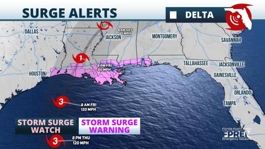
Portions of the northern Gulf Coast are under a storm surge watch, including the Alabama-Florida border, and a hurricane watch has been issued for the northern Gulf coast from High Island, Texas, eastward to Grand Isle, Louisiana.
As of 11 a.m., Delta had maximum sustained winds of 105 mph, with higher gusts, and moving to the northwest at 17 mph.
A sensor on Cancun reported peak sustained winds of 84 mph and a wind gust to 106 mph as Delta passed nearby early Wednesday.

Delta is forecast to produce storm surge of as much as 8-12 feet along the northern coast of the Yucatan, and rainfall totals of 4-6 inches – with as much as 10 inches in isolated areas.
Ray Hawthorne, a meteorologist with the Florida Public Radio Emergency Network, said some weakening is likely Wednesday as it moves over land, but it’s likely to re-intensify – possibly reaching Category 4 strength -- over the Gulf of Mexico.
“Delta is forecast to regain Category 3 status Thursday morning,” Hawthorne said. “Confidence is increasing that Delta will make landfall some time Friday over the Louisiana Gulf coast; however, Storm Surge Watches extend as far eastward as the Alabama-Florida border, where dangerous surges are possible depending on the exact track.”
Cooler water, stronger wind shear, and dry air near the coast may cause Delta to weaken some as it approaches the coast on Friday, but it is expected to cause potentially life-threatening impacts to the coastline. So far, the geographic extent of Delta’s hurricane and tropical storm force winds have been confined, but the wind field is expected to grow wider in the Gulf of Mexico.
Delta is expected to make landfall as the 10th tropical storm or hurricane this season — which would be a record for the number of landfalls. Hurricane records extend as far back as 1851.
Outer fringe rain bands are possible as far as the western Florida Panhandle late Friday and into Georgia, the Tennessee Valley, and the Carolinas over the weekend. Forecasters at National Weather Service offices along the Gulf coast said some coastal flooding was possible into the Florida Panhandle Friday and Saturday, even though the hurricane was expected to make landfall farther west.
Information from the Florida Public Radio Emergency Network was used in this report.


