

Jeff Huffman
Jeff Huffman is Chief Meteorologist at the University of Florida in Gainesville. In addition to his full-time position at the university's radio and television stations, WUFT-FM/TV and WRUF-TV, the latter of which he co-founded, Huffman also provides weather coverage to public radio stations throughout Florida
-
 Larry is a major hurricane in the central Atlantic, and there are no tropical threats to Florida in the next five days.
 -
 The traditional peak of hurricane season is just under two weeks away.
 -
 The western half of the Florida Panhandle can expect gusty rain squalls Monday morning that will spread east toward Panama City and Tallahassee by Monday afternoon.
 -
 Outer rain bands from Ida moved through much of the Florida Panhandle Sunday morning, and in a few cases prompted tornado and flash flood warnings.
 -
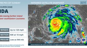
 At 11 a.m., the eye of the extremely dangerous category 4 hurricane Ida was nearing the southeastern coast of Louisiana.
 -
 Tropical Depression Fred is expected to regain tropical storm strength by the time it approaches Southwest Florida Friday night, and a Tropical Storm Watch has been issued for the entire Florida Keys, and from Bonita Beach south to the Florida Bay.
 -
Wind and surge impacts could vary greatly in some places depending on Fred's track, but the greatest hazard to most Floridians will be heavy rain and potential flooding.
-
 One of the potential developments is likely to be approaching Puerto Rico Tuesday, then the Florida Straits or Bahamas by week's end.
 -
 The heaviest rain is expected immediately along the Gulf Coast from Tampa to Cedar Key, where an additional 3-4 inches are possible.
 -
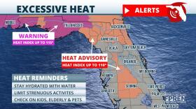 Areas east of Tampa are under a Heat Advisory, meaning feels-like temperatures are expected to be between 110 and 115.


