-
 After a few days of frigid conditions, mild temperatures will return to the greater Tampa Bay region — but with higher rain chances.
 -
 Some areas in the greater Tampa Bay region could see temperatures dip into the mid to upper 20s.
 -
 Wind chills are expected to dip into the 30s across much of the greater Tampa Bay region on Monday night, with sub-freezing temperatures likely on Wednesday morning.
 -
 Continuous rainfall is expected across the watch area on Saturday as the cold front becomes nearly stationary over the area.
 -
 A strengthening low pressure system is anticipated to move northeastward this week dragging a cold front towards the Sunshine State to ring in the New...
 -
 Ice is usually ephemeral; it doesn't last that long before melting. But some ice on our planet has stayed frozen for millions of years, according to scientists on a quest to find the oldest ice.
 -
 Monday marks the start of warm, pleasant work week before the next cold front around Thursday night brings another round of rain and chilly conditions.
 -
 This is ahead of a cold front that will bring frigid conditions across much of the greater Tampa Bay region.
 -
 It will start with possible sea fog on Christmas Eve morning, followed by rain, potentially strong storms, and a cold Christmas Day and weekend.
 -
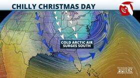 It could be a rainy Christmas Eve, but expect a clear and cold Christmas Day.
 -
 The storms will move in Wednesday afternoon and could be severe, with clearing overnight.
 -
 A gradual warming trend will bring this recent cold blast to an end, with rain on the way.

© 2025 All Rights reserved WUSF
Play Live Radio
Next Up:
0:00
0:00
Available On Air Stations


