-
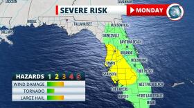
 A weak tropical system could drift back toward the state on Monday and Tuesday.
 -
 The greater Tampa Bay region can expect potentially strong storms starting Friday night.
 -
 The front will produce a more southeasterly wind and drive deep moisture from the Gulf of Mexico.
 -
 Tampa should see storms starting around 3 p.m., with the rains moving into the Gulf of Mexico around sunset.
 -
 CSU forecasters have raised their predictions from 17 named storms and eight hurricanes to 20 storms and nine hurricanes.
 -
 "This is a shelter-in-place operation, unless you are in a low-lying area," said Barry Burton, Pinellas County Administrator.
 -
 The 2 a.m. update from the National Hurricane Center reduced Elsa back down to a Tropical Storm, as it continues to bring heavy rains and gutsy winds to the greater Tampa Bay region.
 -
 The storm quickly strengthened overnight and is forecast to enter the Caribbean on Friday night.
 -
 Tropical Storm Elsa is located well east of the Windward Islands, but is forecast to move quickly into the Caribbean this weekend.
 -
 The exact path is highly uncertain, and any direct interaction with the islands of Hispaniola or Cuba also complicate the forecast.
 -
 The highest risk of the strongest storms is between 3 p.m. and 10 p.m. Tuesday and Wednesday.
 -
 The best chances for rain along the West Coast are Tuesday and Wednesday as moisture is drawn back across the state.

© 2025 All Rights reserved WUSF
Play Live Radio
Next Up:
0:00
0:00
Available On Air Stations


