-
 Some portions of the greater Tampa Bay region could see record temperatures by Thursday.
 -
 Ready for a beach weekend? Temperatures are forecast to climb into the low to mid-80s across the greater Tampa Bay region.
 -
 Tuesday will mark the first day of what could be several days of dry and mild conditions across Florida as a surface high pressure system builds in from the west.
 -
 The greater Tampa Bay region is under a marginal risk for showers and thunderstorms.
 -
 Scattered showers and thunderstorms, some of which could be strong, are anticipated across the Sunshine State for one more day before a brief dry period returns to the state.
 -
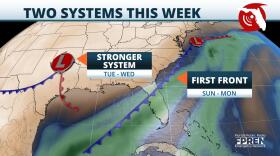 Once the first cold front moves completely through the state, a second and potentially more powerful one is expected to approach from the west.
 -
 Meteorologists say it's harder to track tropical storms than major hurricanes because other forces in the atmosphere can easily change their paths. That's what happened with Eta this week.
 -
 Colorado State University (CSU) released its final Atlantic hurricane season forecast for 2020, raising the number of tropical storms and hurricanes from…
 -
 Monday 8 am Update: The National Hurricane Center has increased the chances of tropical development in the Bay of Campeche to 80 percent, and Senior...
 -
 Changes Floridians have made as a result of coronavirus could turn out helping them during hurricane season.Ray Hawthorne is a meteorologist with the…
 -
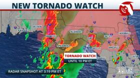
 Damaging winds, large hail, and tornadoes are possible across North Florida beginning as early as midday Thursday, as a powerful low pressure storm...
 -
 Wind damage, hail, and even a tornado are possible across portions of north and central Florida Saturday. A second and more widespread outbreak of...

© 2025 All Rights reserved WUSF
Play Live Radio
Next Up:
0:00
0:00
Available On Air Stations


