-
 One of the most common types of fraud comes in the form of general contractors who flood into the area after a disaster.
 -
 More than a foot of rain fell across portions of Florida Wednesday into Thursday as Ian moved across the state.
 -
 After some parts of the region received a foot of rain, skies will gradually clear as Ian moves off Florida's east coast tonight.
 -
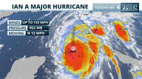 Ian remains forecasted to parallel the Gulf Coast before making landfall with the Sun Coast Thursday. Tornado risk increases from I-4 south today.
 -
 Ian is expected to continue rapidly strengthening. Landfall possible from the Big Bend to the greater Tampa Bay region during the middle to end of the week.
 -
Tropical Depression Nine is currently projected to impact Florida's southwest coast as a hurricane by the middle of next week. As of publishing, South Florida and Central Florida also are within the cone. Governor Ron DeSantis declared a state of emergency for the 24 potentially affected counties on Friday. The governor cites the storm’s potential to escalate into a major hurricane in his declaration.
-
 Spaghetti models are a combination of different model ensembles. It shows the different paths a storm may take, but neither is it a crystal ball.
 -
 Invest 98-L is forecast to move west across the Caribbean before turning to the northwest and into the Gulf of Mexico. It's track after that remains to be seen.
 -
 After Hurricane Fiona and Tropical Storm Gaston, another system could become a tropical depression this week as it tracks west.
 -
 Forecasters say Fiona will stay away from the Florida coastline, but it will likely lead to rough surf up and down the East Coast of Florida.
 -
 Fiona is expected to reach the Virgin Islands and Puerto Rico by Saturday before reaching the Dominican Republic Sunday afternoon.
 -
 Official forecasts indicate a continued westerly track, likely reaching the Leeward Islands by late Friday with heavy rainfall and gusty winds.

© 2025 All Rights reserved WUSF
Play Live Radio
Next Up:
0:00
0:00
Available On Air Stations


