-
 The greater Tampa Bay region is one of the driest areas in the state.
 -
 The United States Department of Agriculture highlighted the western half of Central Florida as “abnormally dry” last week.
 -
 A few record high temperatures could be met or exceeded on Thursday, especially in the greater Tampa Bay region.
 -
 In addition to social media posts, NWS offices will conduct a Tornado Drill on Feb. 9 around 10 a.m. A Tornado Warning message will be aired on all NOAA Alert Radio as part of weekly service testing.
 -
 Temperatures are expected to plunge over parts of the Sunshine State in the wake of the storm line.
 -
 La Niña is going to lead to drier and warmer conditions across the Sunshine State during the winter months, which could help fuel an active wildfire season.
 -
 Expect high temperatures to reach into the lower and middle 80s through the weekend.
 -
 We can expect lingering clouds and a gusty breeze by Sunday.
 -
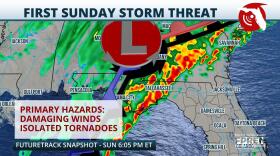
 The storm system likely to wash out many outdoor plans Friday and Saturday across the state and will depart the region quickly Sunday.
 -
 It's a reminder that we still have a month to go until the end of hurricane season.
 -
 Tampa's forecast high of 91 on Thursday would be within 1 degree of its record high set just last year.
 -
 Most of the rain is forecast over the Florida Panhandle while rain chances are likely to stay elevated over the state late this week into next weekend.

© 2025 All Rights reserved WUSF
Next Up:
0:00
0:00
Available On Air Stations