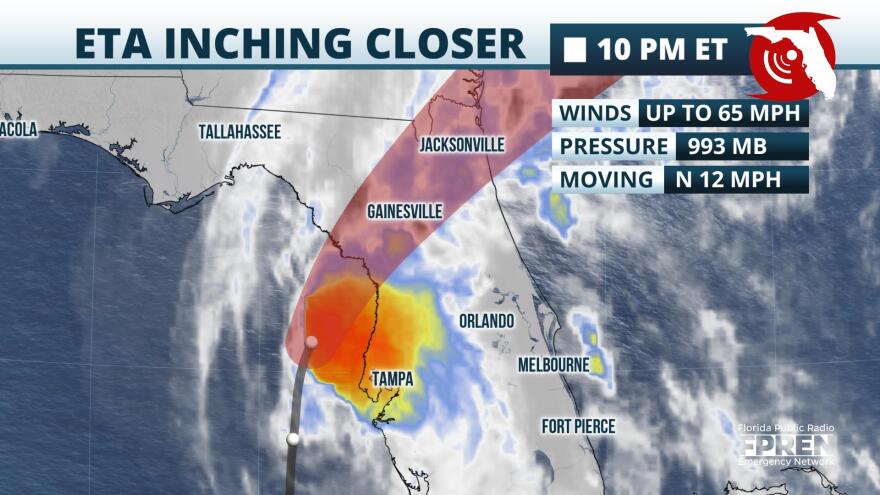
Hurricane watches remain in effect for portions of the greater Tampa Bay region as Tropical Storm Eta’s forecast track took a sharp turn toward the state ahead of a projected Thursday landfall along Florida’s Nature Coast, prompting schools to close across the region.
A Tropical Storm Warning has been issued from Boca Grande to the Suwannee River, including Tampa Bay and Charlotte Harbor, and from the Flagler-Volusia County line to St. Andrews Sound, Georgia.
A Storm Surge Warning has been issued from Bonita Beach to the Suwannee River, including Tampa Bay and Charlotte Harbor.
And a flash flood warning is in effect for Hillsborough, Pinellas, Pasco, Manatee, and Sarasota counties until 1:15 Thursday morning.
Between three and five inches of rain has already fallen. The National Hurricane Center expects with maximum total accumulations of four to to six inches.
A Flash Flood Warning is in effect for #Hillsborough, #Manatee, #Pasco, #Pinellas, and #Sarasota County until 1:15 AM EST. Between 3 and 5 inches of rain has fallen from #Eta so far. Avoid flooded roadways as more rain is expected. #flwx pic.twitter.com/C5Qks6yPpk
— Florida Storms (@FloridaStorms) November 12, 2020
Numerous tornado watches were issued earlier Wednesday afternoon and evening throughout the region from Sarasota and Manatee counties to Pinellas and Hillsborough counties. A few tornadoes are possible overnight over parts of western and central Florida.
The Sunshine Skyway Bridge was closed shortly before 11 a.m. due to high winds, while the Florida Highway Patrol closed the Courtney Campbell Causeway just after 10:30 p.m. due to water over the roadway.
Eta weakened to a tropical storm Wednesday afternoon after briefly becoming a hurricane with maximum sustained winds of 75 mph as of Wednesday morning at 7:35.
As of 10 p.m., Eta was located about 55 miles northwest of St. Petersburg and 60 miles west-northwest of Tampa and moving north at 12 mph, according to the hurricane center. Maximum sustained winds are 65 mph with higher gusts.
Even though the storm is moving north of the greater Tampa Bay region, rain bands have already been lashing the Suncoast, producing possible tornadoes and wind gusts up to 60 mph.
Megan Borowski, meteorologist with the Florida Public Radio Emergency Network, says even through weakening is expected overnight as Eta moves toward the Nature Coast, those hazards will continue and spread farther inland.
“Rounds of torrential rain are expected to douse not only the Nature Coast tonight, but as far inland as Lake and Sumter counties,” Borowski said. “At times, rainfall rates could exceed two inches an hour in these areas."
Storm surge remains a major concern, with videos and photos showing Bayshore Boulevard in Tampa partially underwater, along with flooding in sections of Gulfport, the Shore Acres neighborhood of St. Petersburg, and Tarpon Springs.
The water could reach between three to five feet above ground from Anclote River to Boca Grande, including Tampa Bay, and two to four feet from Boca Grande to Bonita Beach, if the peak surge occurs near the time of high tide — which is within a few hours of midnight Thursday.
High tide has passed near Clearwater... But areas inside Tampa Bay won't see high tide 'till 11pm-12am so #StromSurge will likely get worse before it gets better. #TurnAroundDontDrown #flwx
— NWS Tampa Bay (@NWSTampaBay) November 12, 2020
Slow weakening is expected as Eta approaches the west coast of Florida overnight, followed by more rapid weakening after landfall occurs on Thursday.
"I believe conditions will probably be at their worst...hours right along the coast, especially up in Pinellas County and points north," said FPREN meteorologist Jeff Huffman. "Those heavier rain bands will still rotate inland through midnight, then conditions should gradually approve across our area toward daybreak."
Maximum sustained winds are near 65 mph with higher gusts.
Tropical storm-force winds extend outward up to 115 miles from the center. Albert Whitted Airport near St. Petersburg reported sustained winds of 40 mph and a gust of 52 mph. Gusts of up to 59 mph were reported elsewhere in the region.
"The storm is moving quickly, so rainfall amounts are likely to be less than what occurred in Southeast Florida a few days ago," added FPREN meteorologist Ray Hawthorne. "Widespread amounts of 3 to 6 inches are likely along the west coast of Florida from the Fort Myers area to Tampa-St Pete and the Nature Coast — extending inland toward The Villages and Ocala. Isolated higher amounts are possible."

"Tropical storm conditions may continue for several more hours, especially near and north and east of Tampa, as those rain bands continue to rotate inland," said Huffman.
Atmospheric conditions are still expected to be hostile to the storm as it moves north over the eastern Gulf of Mexico, and the official forecast continues to call for gradual weakening after Wednesday. However, the rate of weakening and speed of the storm are still very much in question due to large spreads in how the models handle several external factors that will likely play a role in Eta's fate.
Information from the Florida Public Radio Emergency Network was used in this report.


