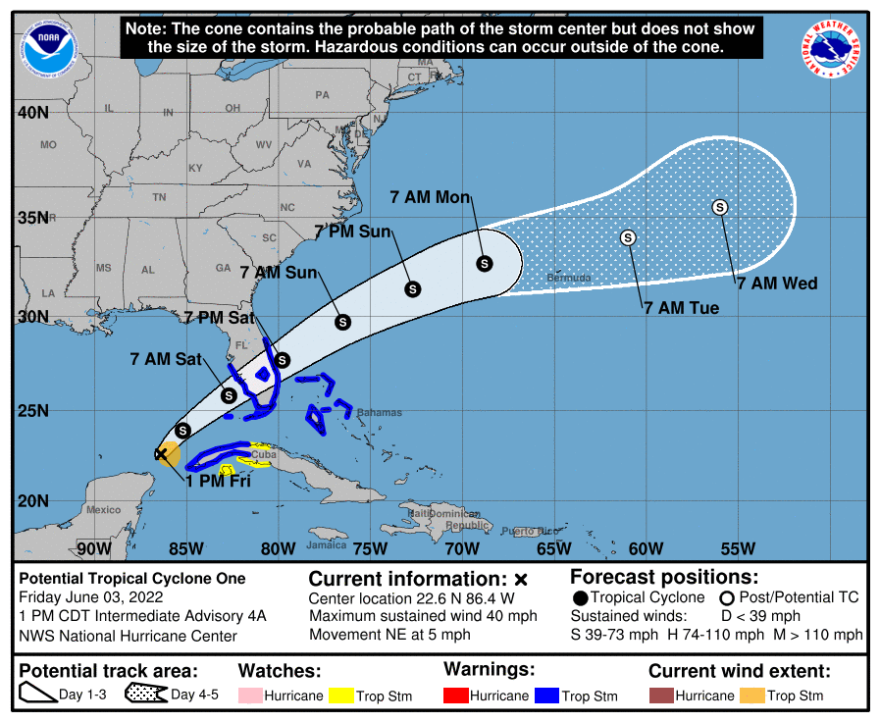
A Tropical Storm Warning has been issued for portions of the greater Tampa Bay region as a system that is expected to dump heavy rain on South Florida is inching its way toward Florida.
Forecasters with the National Hurricane Center say Potential Tropical Cyclone One could become a tropical storm later Friday and further strengthen as it approaches the state on Friday.
As of Friday morning, the warning was in place from Anna Maria Island to the Keys on the West Coast, and from Cape Canaveral to the south on the East Coast.
Megan Borowski, meteorologist with the Florida Public Radio Emergency Network, says tropical storm conditions as a result of are possible in these areas over the next 48 hours.
"The disturbance over the southern Gulf is expected to strengthen into a Tropical Storm later (Friday), and come ashore the Lee Island Coast sometime on Saturday," Borowski said. "While tropical storm force wind gusts will be possible over Central and South Florida, I'm more concerned about rainfall from this system. Between (Friday) and Sunday, upwards of 10 inches accumulations are possible over South Florida."
Borowski said the rain shield from this system will push into the Keys, South, and Central Florida today from southwest to northeast. She says that in areas where heavy rain persists, flash flooding will be a major concern.
As of Friday afternoon, the National Hurricane Center said the system was located about 395 miles southwest of Fort Myers and moving to the northeast at 5 mph. Maximum sustained winds are 40 mph with higher gusts.
It is forecast to increase in forward speed later Friday as it moves across the Gulf of Mexico, and across the southern and central portions of the state on Saturday.
Forecasters say it will cross the state and move into the Atlantic north of the Bahamas on Saturday afternoon through Sunday, where it could further strengthen.
Portions of South Florida and the Keys could receive 4-8 inches of rain, with maximum isolate totals of 12 inches that could produce flash flooding.
Some coastal areas along Florida's West Coast could see storm surge of 1-2 feet.


