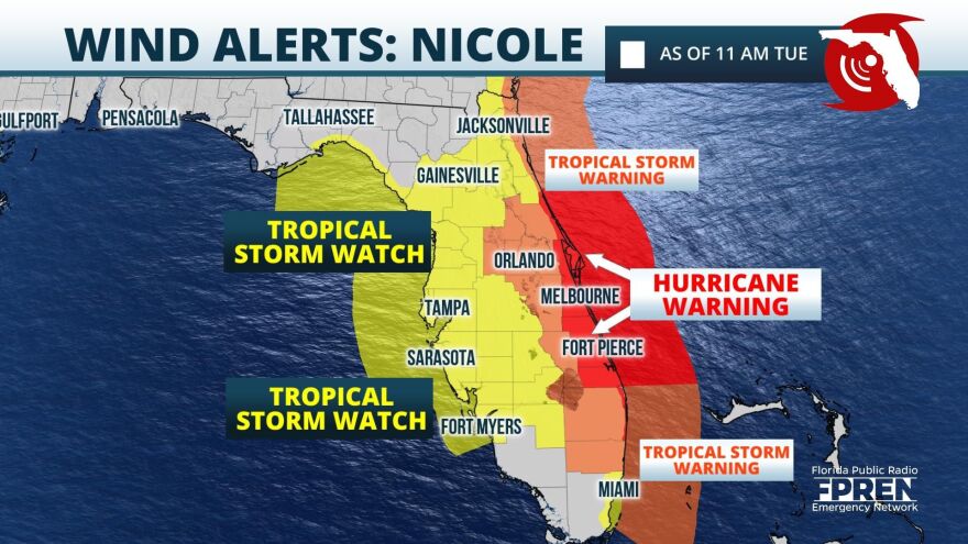
Portions of Florida's Atlantic coast are under a hurricane warning as what is now Tropical Storm Nicole approaches the state.
The National Hurricane Center upgraded Nicole on Tuesday morning.
A hurricane warning is in effect from Boca Raton to the Flagler-Volusia county line, and the state's west coast — from Fort Myers into the Panhandle — is under a tropical storm watch.
A storm surge watch has also been issued from Tarpon Springs to the Suwannee River.
A watch is issued when forecast conditions are possible within 48 hours. A warning is issued when forecast conditions are expected within 36 hours.
As of 10 a.m., Nicole was about 460 miles east of West Palm Beach and moving west at 9 mph. Maximum sustained winds were 50 mph with gusts.
Megan Borowski, meteorologist with the Florida Public Radio Emergency Network, says Nicole is forecast to intensify and will likely be a hurricane when it makes landfall along Florida's Atlantic Coast on Wednesday night.
"Nicole is in an environment where waters are warm and upper-level winds are favorable for strengthening, and we’ll likely see that happen [Tuesday]," Borowski said. "But regardless of whether Nicole is a tropical storm or hurricane at landfall, it will pose life-threatening hazards, namely flooding rainfall and up to 5 feet of storm surge along the Atlantic coast."
Forecasters with the National Hurricane Center say Nicole will bring 3 to 5 inches of rain across the state, with isolated totals of 7 inches possible.
Nicole could also produce a storm surge of 2 to 4 feet from the Anclote River to the Suwannee River, and 1 to 3 feet from Longboat Key to the Anclote River — including Tampa Bay.
The Atlantic hurricane season runs from June 1 through Nov. 30. The last storm to hit Florida in November was Tropical Storm Eta, which made landfall in Cedar Key, on the northwest coast, on Nov. 12, 2020.
Information from the Florida Public Radio Emergency Network and the Associated Press was used in this report.


