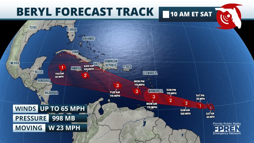
Tropical Storm Beryl is forecasted to become a major hurricane just before arriving to the Windward Islands. The latest forecast from meteorologists at the National Hurricane Center predicts that Beryl will become a hurricane later Saturday night, and a major category 3 hurricane with sustained winds up to 115 mph by Monday morning.
The system was first identified as Tropical Depression Two on Friday evening. A few hours later, the storm had organized enough to be classified as a tropical storm and it was given the name Beryl late Friday night. By late Saturday morning, Beryl had continued to strengthen: Maximum sustained winds were 65 mph and pressure dropped to 998 mb. The storm’s position was 820 miles east of Barbados just before noon on Saturday.

Over the next few days, Beryl is expected to travel through an environment that is quite supportive of tropical convection. Forecasters expect the storm to become the first hurricane of the 2024 Atlantic hurricane season by early Sunday morning as it tracks due westward toward the Lesser Antilles. By early Monday, Beryl will approach Barbados, St. Vincent, Grenada, St. Lucia, and Martinique and it is expected that the storm will have strengthened into a major category 3 hurricane.

In anticipation of Beryl’s arrival to the Lesser Antilles, a Hurricane Watch has been issued by local governments over Barbados, St. Lucia, St. Vincent and the Grenadines, and Grenada. A Tropical Storm Watch has been issued for Martinique and Tobago.

Steering winds should guide Beryl through the above-mentioned islands on Monday, and then into the Caribbean Sea during the middle of the week. Some weakening is expected during this period, although Beryl should still retain hurricane strength. It is important to note that the forecast track beyond Tuesday is uncertain and could change. Interests throughout the Caribbean, including the Greater Antilles, are urged to monitor the forecast closely.
As of Saturday, there are no immediate threats from Beryl to the Southeast. Even so, residents and visitors alike across the region are advised to monitor conditions and forecasts during the middle and end of the week.


