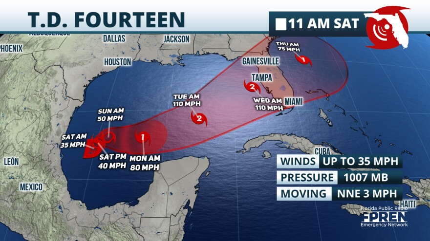
Tropical Storm Milton formed in the western Gulf of Mexico on Saturday afternoon according to experts at the National Hurricane Center. This tropical development comes less than two weeks after Hurricane Helene caused devastating damage over parts of the Southeast and Mid Atlantic.
According to meteorologists at the National Hurricane Center (NHC), an area of thunderstorms over the western Gulf of Mexico was being monitored since the end of September, when Helene was making landfall over Florida’s Big Bend. As of late Saturday morning, these thunderstorm cells had organized enough to be defined as a tropical depression.
At 11 AM Saturday, officials said that winds were up to 35 mph and storm motion was slow, at about 3 mph toward the northeast. The system is expected to linger over the western Gulf of Mexico through the weekend, before it begins to accelerate eastward by the early workweek. By the early to middle part of the upcoming week, forecasters at the NHC anticipate that Milton will strengthen into potentially a category two hurricane.

Regardless of amount of strengthening that Milton undergoes, heavy rain is expected over the southern half of the Florida peninsula this week. The preliminary rainfall forecast through Saturday, Oct. 12 is between four and 8 inches for locations along and south of I-4 and for the immediate Atlantic Coast. The forecast for exact totals will likely change over the next few days, but the overall theme will remain consistent: Heavy rainfall for parts of the peninsula will pose a mounting threat for flash flooding next week.
Interests over the Florida peninsula are urged to monitor the forecast closely and to check their family’s hurricane plan.


