Less than two weeks after Hurricane Helene slammed into Florida’s northern Gulf coast, Hurricane Milton made landfall near Siesta Key on October 9th. The storm packed dangerous Category 3 winds of 120 mph, knocking out power to millions of people in Florida and caused at least two dozen deaths.
Hurricane Milton death toll up to 25 a week after landfall in Florida https://t.co/PLmVYJXorZ
— Palm Beach Daily News (@ShinySheet) October 16, 2024
Milton is the third hurricane to hit Florida this year. No other year on record has more than three hurricane strikes. After an early to mid season pause, the 2024 Atlantic hurricane season is now above normal by all measures.
#Hurricane #Milton is the 3rd Florida landfalling hurricane this year. 2024 has now tied 1871, 1886, 1964, 2004 and 2005 for the most Florida landfalling #hurricanes on record in a single season. pic.twitter.com/1sKAkTvYV2
— Philip Klotzbach (@philklotzbach) October 10, 2024
Preliminary estimates of the total damage and economic loss from historic Hurricane Milton is between $160 billion and $180 billion dollars. Milton will go down as one of the most damaging and impactful storms in Florida’s history. Hurricane Helene’s total damage and economic loss is estimated around $225-250 billion dollars.
How much are damage estimates for Milton? Hint: It's in the billions https://t.co/imF0oNaYV1
— Naples Daily News (@ndn) October 12, 2024
Tornadoes:
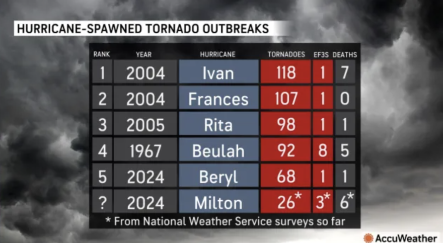
A staggering 126 tornado warnings were issued in Florida the day Milton made landfall. A total of 45 tornado reports were received, but the NWS has only surveyed 32 of the tornado reports so far, as of Wednesday evening. As they continue to perform surveys, that number could go up if additional damage is found in new areas, or down, if multiple fields of damage are found to be from the same tornado.
[Overview] Revisiting the Milton Tornado Outbreak:
— NWS Miami (@NWSMiami) October 16, 2024
- 126 Tornado Warnings issued by NWS offices (55 by NWS Miami) on October 9th 2024
- 15 Confirmed Tornado Reports in NWS Miami Area of Responsibility
- PNS here: https://t.co/iLUVYORnfC
- Tracks here: https://t.co/HU4siFUwGN https://t.co/GJKOxrQy0c pic.twitter.com/sYSg2J9BTR
Milton’s tornado outbreak places it 2nd among tornado warnings issued in a given day. Number 1 and 3 are from super tornado outbreaks in 2011. Number 5 is from catastrophic Hurricane Rita.

Tornadoes are common before and after landfalling hurricanes. Earlier this season, Hurricane Beryl spawned 68 tornadoes from Texas to Canada. However, that number is even eclipsed by Hurricane Beulah in 1967, Rita in 2005, Frances in 2004, and Ivan, which spawned 118 tornadoes in 9 states in 2004 after making landfall near Gulf Shores, Alabama. To read more about the historic 2004 hurricane season, click here:
Here's more on the historic 2004 hurricane season

Storm Surge
The storm surge at Naples, Florida, reached 5.78 feet above normal tide, nearly a foot higher than Hurricane Helene on Sept. 26 and almost 3 feet above Hurricane Debby on Aug. 4.

At Fort Myers, the gauge rose to 5.26 feet, slightly above the crest reached during Hurricane Helene at 5.12, but short of the 50-year record set by Hurricane Ian of 7.26 feet on Sept. 28, 2022.
Anti-surge
Instead of the water rising in Tampa Bay, a tidal gauge downtown, just north of the storm's landfall experienced a "blowout tide" or anti-storm surge. This happens when high winds from a tropical storm or hurricane blow offshore from the land instead of the ocean, which temporarily pushes water in bays out to sea. The water level fell to nearly 5 feet below normal as winds blew water in the bay out into the Gulf of Mexico.
With Hurricane Milton landfall in Sarasota, which is south of Tampa Bay, the counter clockwise spin of the hurricane literally pulls water out of the bay.
— Matt Dursh (@MattDursh) October 10, 2024
Negative storm surge. pic.twitter.com/9OKoevlVOg
Rainfall:
One of Hurricane Milton’s largest and most consequential signatures will be its flooding rains. The total rainfall estimates from Hurricane Milton are estimated to be over 3.4 trillion gallons of water in the Sunshine State. At the St. Petersburg Albert Whitted Airport, 18.87 inches of rain fell during Hurricane Milton. In just one hour, the rain gauge recorded 5.09 inches, an extremely rare rainfall rate. As Milton moved across Florida, several ambient weather rain gauges recorded 16.67 inches in Lakeland, 32 miles northeast of Tampa.
Total rainfall from Hurricane Milton over Florida was 3.4 Trillion gallons. pic.twitter.com/CO342vhheG
— Ryan Maue (@RyanMaue) October 13, 2024
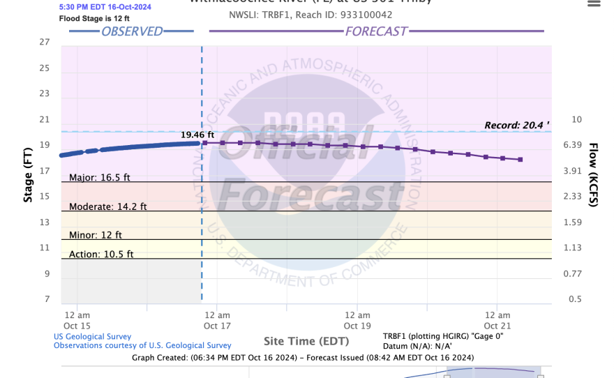
Milton’s flooding rains continue to cause extensive river flooding issues more than a week after it made landfall. Several low lying communities that straddle rivers along the I-4 corridor have already begun making preparations for additional fresh water flooding for the next 10 days or so, as flood waters recede into local rivers and overspill into flood prone communities.
Power outages:
Hundreds of thousands of Floridians lost power from Hurricane Helene. After Hurricane Milton slammed into south central Florida and bisected the state, outages eclipsed 3.5 million. Hardee and Highlands counties reported that nearly 100% of customers were in the dark.

Peak Wind Gusts
The strongest wind gust reported during the storm was 105 mph at a WeatherFlow weather station in the Egmont Channel, southwest of St. Petersburg. The Bradenton and St. Petersburg airports also gusted to 102 and 101 mph, respectively.
Other notable numbers
Hurricane Milton's central pressure fell to 26.64 inches of mercury (902 mb) on Oct. 8, making it the fifth-strongest hurricane ever observed in the Atlantic Basin and the second-lowest for this late in the year. Milton's sustained winds were estimated at 180 mph, and only five Atlantic hurricanes have had estimated winds higher than Milton's.
Hurricane Milton struck the Florida coastline with a central barometric pressure of 954 mb. To put that into historical context, it tied for 69th place. There have been 73 other hurricanes that struck with the same or higher intensity (lower pressure = stronger storm). pic.twitter.com/9qNAqKWXff
— Chris Martz (@ChrisMartzWX) October 13, 2024
2024 Hurricane Season
Hurricane Milton is the fifth hurricane to make landfall on the Gulf Coast this season, after Beryl, Debby, Francine and Helene. The 2005 and 2020 hurricane seasons also had five. Only the year 1886 had more, with six hurricanes making landfall in the Gulf that season.


