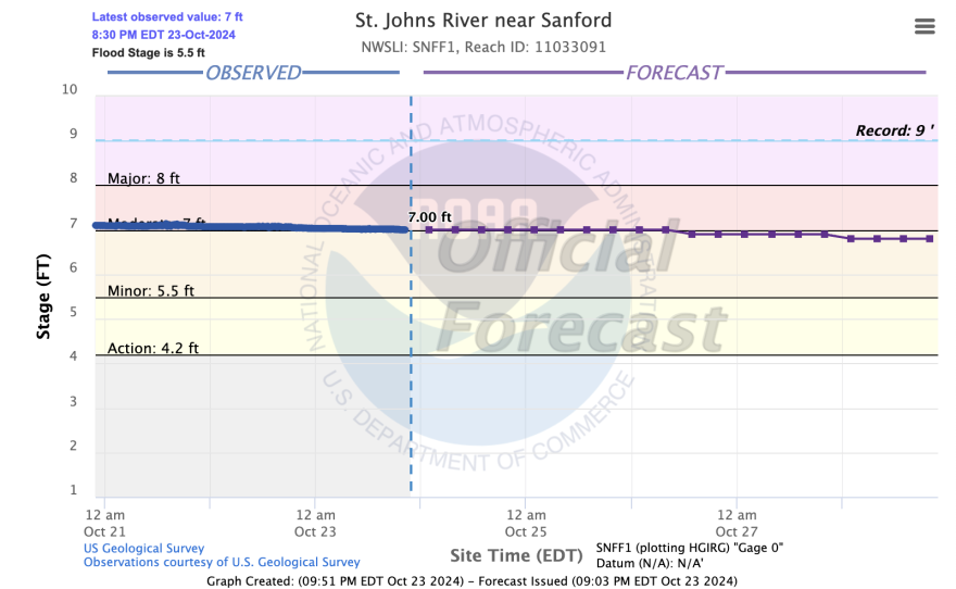
It’s been 2 weeks since Hurricane Milton roared into western central Florida and then bisected the State with hurricane winds. Milton eventually moved off of eastern north Florida a day later. Several central and northern Florida lakes and rivers continue to remain above flood stage. Officials say it could be weeks if not months before water levels return to normal.
More than a week and a half after #HurricaneMilton made landfall residents are still experiencing devastating flooding. This is in the Ridge Manor area, which is near the Withlacoochee River. Residents say the river has continued to rise over the last few days. @FOX13News pic.twitter.com/JNbabaZnVE
— Jordan Bowen FOX 13 (@JordanBowenFOX) October 19, 2024
Residents in some of the hardest flooded regions say help is coming too little too late. Some residents in Orange City are still relying on boats to get around their neighborhoods.
Flooding is so bad in Orange City after Milton that leaders are building a temporary causeway | Click on the image to read the full story https://t.co/5ZoCeA5BzG
— WESH 2 News (@WESH) October 21, 2024
Some rivers along interior Florida remain in major flood stage. While the water is receding, it’s a slow drain for many flood stricken areas.
On top of the stress and strain of rebuilding after back to back hurricanes, many popular “snowbird” destinations in Florida are struggling to reopen before the influx of seasonal snowbird residents arrives.
Hurricane Milton ravaged one of the most popular areas for 'snowbirds' on Florida's Gulf Coast #GulfCoast #Hurricane #CentralFlorida #Weatherhttps://t.co/OHTJgCTnNj
— Stephen Ames Berry (@writerredux) October 23, 2024
“Snowbird” season generally runs after Halloween to around Easter. According to the Census Bureau, roughly 1.5 million people relocate to Florida to escape harsh winters up north. Florida gets more temporary residents each winter season than any other U.S. state in the country. But damage along Florida’s west coast could steer some much needed tourist dollars away.
After Milton's wrath, experts see a reshaping of Florida tourism. "Many of the mom-and-pops may take the insurance payout and decide not to rebuild." https://t.co/YvpF8IRQOT via @TravelWeeklyUS
— Jean Gruss (@JeanGruss) October 22, 2024
To compound the flooding, king tides and strong onshore flow off the Atlantic are working to add additional resistance to the river drainage process - which is causing the St Johns river to rise again.

Because of this, the river is forecast to remain above major flood stage at least into next week with conditions expected to level off sometime in November.


