-
 Tropical Storm Grace formed early Saturday morning and is poised to take a track that is similar to Tropical Storm Fred.
 -
 Residents of Central and North Florida are likely to see heavy rain, pockets of flash flooding, and a chance of isolated tornadoes Sunday into Monday.
 -
 The Florida Keys are under a tropical storm warning, and a tropical storm watch was issued from Englewood to Bonita Beach with Fred expected to pass near the greater Tampa Bay region on Sunday.
 -
 Tropical Depression Fred is expected to regain tropical storm strength by the time it approaches Southwest Florida Friday night, and a Tropical Storm Watch has been issued for the entire Florida Keys, and from Bonita Beach south to the Florida Bay.
 -
Wind and surge impacts could vary greatly in some places depending on Fred's track, but the greatest hazard to most Floridians will be heavy rain and potential flooding.
-
 The system became a tropical storm late Tuesday night and remains on a path that could bring it near the greater Tampa Bay region by Sunday morning.
 -
 Tropical storm warnings are in effect for Puerto Rico as Potential Tropical Cyclone 6 moves toward a possible pat h toward the Tampa Bay area by this weekend.
 -
 One of the potential developments is likely to be approaching Puerto Rico Tuesday, then the Florida Straits or Bahamas by week's end.
 -
 A largely quiet tropical Atlantic over the past three weeks may soon change in response to changes in the atmosphere over the global tropics.
 -
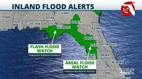 Rainfall totals of 4-8 inches are possible along the Nature Coast to near Gainesville and to areas just north of the Interstate 4 corridor.
 -
 Higher rain amounts are possible anywhere in the state where storms are more persistent, with the Nature Coast favored for the locally higher rain totals.
 -
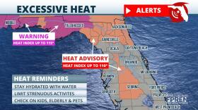 Areas east of Tampa are under a Heat Advisory, meaning feels-like temperatures are expected to be between 110 and 115.

© 2025 All Rights reserved WUSF
Play Live Radio
Next Up:
0:00
0:00
Available On Air Stations


