-
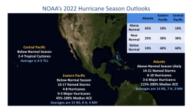
“Not anywhere in the past have we had six consecutive seasons above normal,” Rosencrans said.
-
Be prepared for possible storms as you're watching the July 4 fireworks.
-
Relative humidity fluctuates throughout the day and is highest during the morning because the air temperature and dew point tend to be close.
-
If your pet is showing signs of heat stress, you will want to cool them down without introducing another extreme temperature.
-
Feels-like temperatures will once again pass 100 degrees across parts of the greater Tampa Bay region.
-
The second heat wave over the course of two weeks is slated to arrive to most of Florida by Wednesday.
-
A record setting heat wave is developing over the Southeast, including over the state of Florida.
-
Forecasters are monitoring the low, as it is positioned over the warm waters of the Gulf Stream, which could enhance thunderstorm activity and allow the system to acquire subtropical characteristics.
-
It will likely approach the I-4 corridor Thursday night.
-
A line of severe storms is expected to push through the Panhandle on Tuesday night, and North and Central Florida on Wednesday. Wednesday evening, storms are expected to dwindle as they approach I-4.
-
The cells should impact the greater Tampa Bay region near midnight through the predawn hours.
-
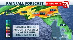
Heavy rainfall will begin in the Florida Panhandle and move across the state.
Play Live Radio
Next Up:
0:00
0:00
Available On Air Stations


