-
 Larry is a major hurricane in the central Atlantic, and there are no tropical threats to Florida in the next five days.
 -
 The traditional peak of hurricane season is just under two weeks away.
 -
 The western half of the Florida Panhandle can expect gusty rain squalls Monday morning that will spread east toward Panama City and Tallahassee by Monday afternoon.
 -
 Outer rain bands from Ida moved through much of the Florida Panhandle Sunday morning, and in a few cases prompted tornado and flash flood warnings.
 -
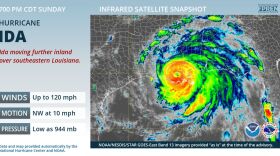
 At 11 a.m., the eye of the extremely dangerous category 4 hurricane Ida was nearing the southeastern coast of Louisiana.
 -
 The system is expected to become Tropical Storm Ida and then strengthen into a hurricane as it approaches the northern Gulf coast this weekend.
 -
 One system could strengthen as it enters the southern or western Gulf of Mexico this weekend.
 -
 A pattern is presently favoring a ridge over the southeastern U.S., which tends to keep Caribbean systems in the western Gulf.
 -
 Tropical Depression Grace no longer appears to be a threat to Florida, while potential tropical storm Henri will pass south of Bermuda during the next few days.
 -
 Tropical Storm Fred made landfall in Cape San Blas in the Florida Panhandle, and that area could receive up to a foot of rain. The greater Tampa Bay region could experience rain bands and dangerous rip currents.
 -
 Forecasters say heavy rainfall from Grace could impact portions of Cuba, the Bahamas, and Florida by mid to late week — but the forecast uncertainty is much higher than usual.
 -
 The heaviest bands directly associated with Fred are expected to stay offshore from the greater Tampa Bay region.

© 2025 All Rights reserved WUSF
Play Live Radio
Next Up:
0:00
0:00
Available On Air Stations


